An earthquake of magnitude 7.9, the biggest ever, hit the island of Hawaii. The earthquake caused enormous damage in Hawaii Island and was felt three hundred miles away.
Every year thousands of earthquakes hit the state of Hawaii, the vast majority of them occurring on the biggest and youngest of all the islands that form the state, The island of Hawaii, known as the Big Island. On the third of April 1868, this island experienced Hawaii’s biggest earthquake ever, magnitude 7.9, which caused damage all across the hundred-mile-long island. Its epicenter was in the district of Kau on the south coast, on the southeast flank of Mauna Loa, a volcano that rises more than 27,000 feet into the air, higher than Mount Everest if you count its height from the ocean floor where it begins. The earthquake, which could be heard more than three hundred miles away on the Island of Kauai, caused a mudflow, a rare aspect of Hawaii’s many earthquakes, an occurrence that killed thirty-one villagers. It also caused coastal subsidence west of the epicenter and created a tsunami that flooded several villages in Kau and drowned forty-six people.
All along the south coast of Hawaii the earthquake knocked wooden homes off their foundations and, in the villages where straw was the main building material, it tore homes to shreds. Even the more substantial structures of stone were demolished. In the community of Hilo, some distance away on the east coast of the island, every building was damaged. Farther north, almost a hundred miles from the epicenter, in the Kohala Mountains, there were ground waves rising as high as two feet that made it almost impossible for people to stand. Ground fissures of varying depths extended from Pahala to the Kilauea Crater, a total distance of twentyfive miles. Landslides were common all over the island and there was subsidence on the southwest coast to depths of six feet. Much of the destruction was a direct result of the tsunami in which water at times rose as high as forty-five feet. Its impact was also felt beyond the Big Island, on Maui, Lanai, Oahu, and Kauai.
The state of Hawaii is a chain of volcanic islands near the center of the Pacific Ocean. Every part of the state has a volcanic origin. The following is a list of the eight main islands, in descending order of size: Hawaii, Maui, Oahu, Kauai, Molokai, Lanai, Niihau, and Kahoolawe. These eight constitute 90 percent of all the land area of the state but there are numerous smaller islands. There are also many very large islands but they are farther west and are below sea level. The name of the island of Hawaii is a bit of a problem because references to it in books and news reports are often confused with the whole state. It is not only the biggest island; it is more than twice the size of all the other islands combined and it contains the biggest volcano in the state in terms of total mass, Mauna Loa. Because of its location at the eastern end of the state, Hawaii is the youngest volcanic island and therefore the one where most volcanic activity is taking place. The reason for the greatest volcanic activity being at the eastern end of the state is because the hot spot, that is to say the opening down below in the crust of the earth, is directly below the Big Island.
Big Island has five volcanic mountains, approximately twenty miles apart, separated from one another by saddles formed from past lava flows. As the newest island it has none of the coral reefs that are common on the far western, much older islands, and little of its coast has yet been affected by erosion. Maui, Molokai, Lanai, and Kahoolawe, which were once probably a single volcanic peak, are all now separated by distances averaging eight miles and by shallow waters usually three thousand feet deep. Oahu, third in size, is the location of the state capital, Pearl Harbor, The East-West Center, and the well-known tourist attractions of Diamond Head and Waikiki Beach. Kauai and Niihau stand apart from other islands. They are at considerable distances from their nearest neighbors and the water in between is quite deep compared with most of the other islands.
The whole of the state of Hawaii is part of a large volcanic mountain range, most of which is beneath the sea, the islands forming the state being the youngest and, therefore, the highest and most visible parts. The whole mountain chain was formed by what some call a hot spot beneath Big Island in the earth’s mantle. This hot spot does not move relative to motions on the surface of the earth and for the past few million years it has been underneath the Big Island. Hence, the frequencies of earthquakes and volcanic eruptions are more frequent here than anywhere else. The Pacific Tectonic Plate on which all the islands stand does move very slowly from east to west. As it moves it takes all the islands with it so the ones we see today as the farthest west are the coldest and least active because they are farthest away from the hot spot. The Pacific Plate moves northwards and then northwestwards, first at a rate of about three inches a year, then four inches, and this has gone on for the past seventy million years. Mama, magma from areas seventy miles below sea level erupted continually at the location of the hot spot, creating, over time, the volcanic mountains that constitute the state.
The history of the Pacific Plate’s movements is told in the evolution of the Hawaiian-Emperor Chain, a dogleg series of volcanic mountains stretching thousands of miles across the North Pacific from Hawaii to the Kurile Trench, a subduction zone close to the Kamchatka Peninsula. It also provides a concrete illustration of sea floor spreading. The dogleg section, the change of direction when the Pacific Plate switched from moving northward and took a northwesterly course, was caused by collisions between the Indian subcontinent and the Eurasian land mass forty million years ago. Volcanic mountains in the chain that would now be counted as are older than seventy million years were carried down into the Kurile subduction zone. This series of volcanic peaks consists of more than one hundred individual volcanoes, most of them are below the sea. Their ages are progressively older and their heights lower as they move away from the hot spot. The history of any one of these volcanoes can now be better understood because a new one, Loihi, presently under active study, is developing under the sea twenty miles to the east of the Big Island. Its peak is still less than a mile below sea level.
The heights of some of these volcanoes can readily be overlooked because so much of them is below sea level. Take the two highest, for example, Mauna Kea and Mauna Loa, and note that they stand, like all the others, on an undersea platform that rises far above the general level of the seafloor. A single contour line representing one and a half miles of depth can be drawn to encompass all of Kauai, Oahu, Maui, and Big Island. Even this measurement does not reach far enough. The average depth of the ocean floor in this part of the Pacific is approximately three miles. The identification of a hot spot anywhere on the surface of the globe provides one location that is fixed with respect to the earth’s mantle. This is very valuable because all else is relative. All the plates are moving and have no fixed reference to the interior of the earth. It’s the same with midocean ridges, oceans, and continents. These hot spots are found in a number of places all round the world but their behavior over time is difficult to track if they occur on land. It is a much easier task when the spot is in the ocean so the Hawaiian-Emperor Chain is an ideal model for studying the historical process.
Over the long seventy million years that we can trace this chain before the oldest of the volcanoes disappears beneath the Asian continent at Kamchatka, we can see a clear pattern developing for each individual volcano. First, as the Pacific Plate moves westward and volcanic eruptions decrease, the rock that formed the mountain gets cooler and cooler and therefore heavier. This increasingly heavy mass then presses down on the seafloor and pushes it downward. At the same time, erosive forces go to work on the top of the peak, first rain and wind, then ocean waves, until it is almost flat. The end result is a series of underwater volcanic mountains, each the same height above the seafloor, but with the flat top of each progressively deeper and deeper below sea level. The ocean floor had sunk but each mountain ended up as a similar landform.
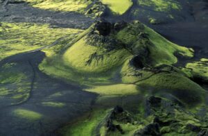
Because of their universal and multi-faceted influence over conditions in the state of Hawaii, we need to be aware of the evolution of a typical Hawaiian volcano before examining its effects in daily life. Although the final appearance and size of a volcano will be unique, each one in the chain evolved and is evolving through the same sequence of stages. First comes the eruption of small quantities of lava deep in the ocean over the hot spot, gradually increasing in quantity until it reaches a peak about half a million years later, after which the amounts decline. Several million years may pass before eruptive activity finally ends and the volcano becomes extinct.
The volcano’s life begins deep down below the ocean surface as submarine eruptions build a steep-sided, small mountain with a shallow caldera. As the young volcano grows, small landslides cut into its steep slopes, scarring them. This first phase lasts about 200,000 years but produces only a small part of the final mass. An increase in the frequency and volume of eruptions marks the second phase along with changes in the composition of the basaltic lava. This is Loihi’s present stage of development and, before it is completed, Loihi will be close to the surface of the ocean and explosive, ash-generating eruptions will become common as lava mixes with water.
The third phase is when the volcano has grown to more than two thousand feet above sea level and explosive eruptions begin to taper off. Lava flows are now low in volume and continue intermittently for several hundred thousand years. The type of lava emitted is shaped by the slope of the ground and the physical properties of the erupted basalt, and is most commonly basalt. Lava that flows into the ocean shatters into sand and gravel-size fragments and these blanket the submarine slopes. During all three phases, the summit caldera repeatedly collapses, fills up, then collapses again. By the end of half a million years, more than 90 percent of the volcano’s mass has been accumulated and it looks like a warrior’s shield, hence it has come to be known as a shield volcano.
Weathering and erosion now take their toll of the high, steep-side mountain. The side of the mountain that is closest to the sea and therefore not supported as well as the landward side slips readily toward the ocean, creating large faults and causing major earthquakes. Occasionally there are catastrophic landslides. Recently, vast fields of debris, some of it in large blocks, have been discovered all around the major islands. These submarine deposits suggest that major landslides must have occurred every 150,000 years on the average. Over time, deep canyons cut into the flanks, often along faults previously created by landslides.
At the same time, the volcano’s enormous weight pushes the underlying lithosphere downward. Mauna Loa, for example, the world’s biggest volcano, has a volume of more than one and a half million cubic feet. Under these conditions the volcano begins to sink and as this happens fringing coral reefs grow at the shoreline with sediments from the reefs accumulating in lagoons. In some Hawaiian Islands, remnants of these ancient reefs can be seen. During times of global cooling when polar ice caps grew and sea levels dropped the volcanic shorelines remained at the same level for long periods of time, allowing numerous large reefs to grow.
Beneath Mauna Loa, because of its enormous weight, the ocean crust is depressed approximately 1,500 feet, forming a hollow known as the Hawaiian Deep. In the adjacent waters the seafloor rises by about the same amount to form the Hawaiian Arch. Kilauea is 250,000 years ahead of Loihi in its evolution. It rose above the surface of the ocean 200,000 years ago and within the following 100,000 years had grown to a height of 2,000 feet above sea level. One of the interesting comparisons between Loihi and Kilauea is that both have three main areas of volcanic activity: the summit and two flanking rift zones. Though widely separated in time it seems that their patterns of growth take similar paths.