Causes & Mechanisms
To understand how natural disasters shape history, we must first understand the scientific forces that drive them. These events arise from complex geological and atmospheric processes. A natural hazard is a physical phenomenon, like a hurricane or an earthquake fault. It only becomes a natural disaster when it intersects with a vulnerable human population, causing widespread loss.
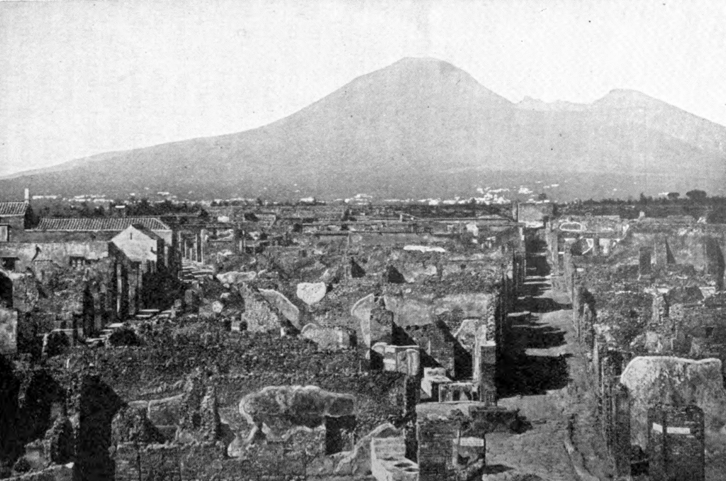
Volcanic eruptions, such as the one that buried Pompeii, are driven by plate tectonics. The Earth’s crust is made of massive plates that are constantly in motion. At subduction zones, one plate slides beneath another, melting rock into magma. This magma, along with trapped gases, can build immense pressure underground. When that pressure is released, it results in an eruption. The eruption of Mount Vesuvius in 79 CE was a Plinian eruption, one of the most explosive types. It sent a column of superheated ash, gas, and rock high into the stratosphere. The most lethal phenomena were the pyroclastic flows, which are fast-moving, ground-hugging currents of hot gas and volcanic matter that can reach speeds of over 400 miles per hour and temperatures exceeding 1,800 degrees Fahrenheit. These flows instantly incinerated everything in their path, which is how the eruption of Vesuvius buried Pompeii and Herculaneum so rapidly.
Earthquakes also originate from plate tectonics. The 1755 Lisbon earthquake occurred along the Azores-Gibraltar Transform Fault, a complex boundary between the African and Eurasian plates. As plates grind against each other, stress builds up in the rock. When the stress exceeds the rock’s strength, it ruptures, releasing energy in the form of seismic waves. The point of rupture is the focus, and the point on the surface directly above it is the epicenter. The energy released is measured by magnitude, a single value representing the total energy (e.g., on the Moment Magnitude Scale). The effects on the ground, such as shaking and damage, are measured by intensity (e.g., on the Modified Mercalli Intensity Scale). The Lisbon earthquake, estimated to have a magnitude around 8.5–9.0, was so powerful that it generated a massive tsunami in the Atlantic Ocean and caused severe shaking felt across Europe and North Africa.
Meteorological events like hurricanes are driven by heat from the ocean. The Galveston Hurricane of 1900 was a tropical cyclone, a rotating storm system that forms over warm ocean waters. These storms draw their energy from the heat and moisture of the sea surface. As warm, moist air rises, it cools and condenses, releasing latent heat that powers the storm. The Earth’s rotation, through the Coriolis effect, causes the storm to spin. The most destructive component of many hurricanes is the storm surge. This is an abnormal rise in sea level generated by the storm’s powerful winds pushing water toward the shore, combined with the low atmospheric pressure at the storm’s center. In Galveston, a low-lying barrier island, the storm surge reached an estimated 15 feet, inundating the entire city and causing the vast majority of the destruction and fatalities.
Tsunamis are most often caused by underwater earthquakes at subduction zones. The 2004 Indian Ocean tsunami was triggered by a megathrust earthquake with a magnitude of 9.1–9.3 off the coast of Sumatra. The earthquake occurred when the Indian Plate suddenly slipped under the Burma Plate, causing a section of the seafloor hundreds of kilometers long to be thrust upward by as much as 20 meters. This vertical displacement lifted a colossal volume of water, creating a series of powerful waves that radiated outward across the entire Indian Ocean at speeds comparable to a jet aircraft. In deep water, the waves are barely noticeable, but as they enter shallow coastal areas, they slow down and their height increases dramatically, resulting in catastrophic inundation.
Modern hazard science, supported by agencies like the USGS for seismic and volcanic activity and the NOAA/NWS for weather events, focuses on monitoring these processes. Early warning systems, from seismometers to weather satellites and deep-ocean tsunami buoys, are crucial for risk reduction. They provide lead time for communities to evacuate and prepare, turning a potential catastrophe into a manageable emergency.