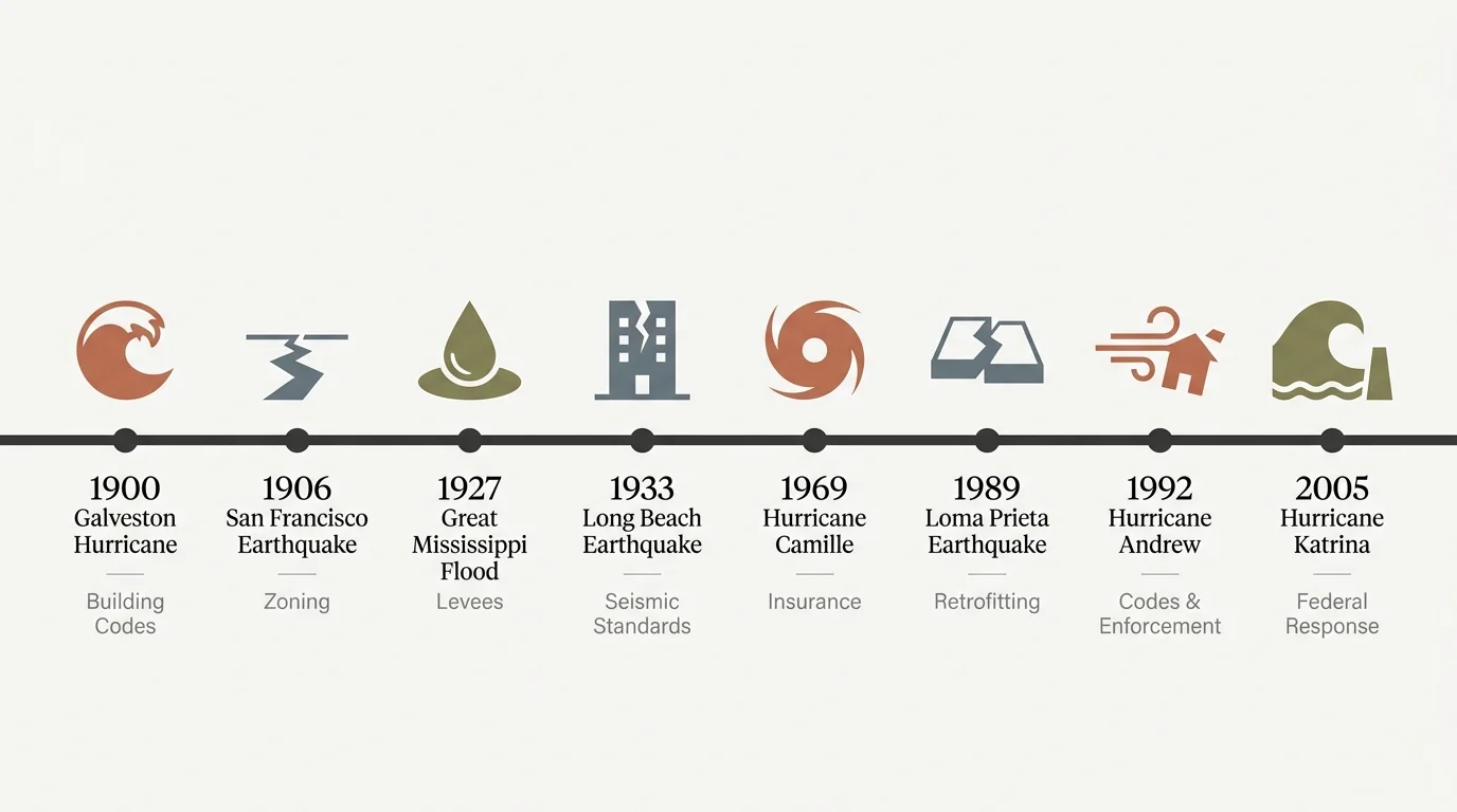
Timeline
The chronology of a disaster directly influences its lethality. Historically, the speed at which a hazard strikes, combined with the lack of advanced warning technology, determined how many people survived. The evolution of our national emergency warning systems directly mirrors the timeline of these eight catastrophic events, shifting from an era of complete surprise to an era of real-time satellite tracking.
In the late 19th and early 20th centuries, natural hazards struck communities with virtually no warning. The timeline of the 1900 Galveston Hurricane illustrates the fatal consequences of technological limitations. On September 8, 1900, the residents of Galveston, Texas, went about their morning routines largely unaware of the massive storm churning in the Gulf of Mexico. Although local meteorologist Isaac Cline observed alarming drops in barometric pressure and rising tides, the central weather bureau in Washington dismissed the severity of the threat. By mid-afternoon, the ocean began consuming the island, and by nightfall, complete destruction had enveloped the city. The lack of an actionable timeline prevented any organized evacuation.
Similarly, earthquakes operate on a timeline of seconds. The 1906 San Francisco Earthquake struck at 5:12 AM on April 18, waking residents with a violent jolt that lasted nearly a minute. Decades later, the 1933 Long Beach Earthquake struck at 5:54 PM on March 10. Because this earthquake hit in the late afternoon, schools sat mostly empty. Had the shaking occurred just three hours earlier, thousands of children would have died beneath the rubble of collapsing brick classrooms. The 1989 Loma Prieta earthquake hit precisely at 5:04 PM on October 17. The timing intersected with the evening rush hour and the broadcast of the World Series, capturing the disaster live on national television but also catching thousands of commuters on vulnerable elevated highways.
The 1927 Great Mississippi Flood presents a stark contrast in its timeline. This disaster unfolded agonizingly slowly over several months. Heavy rains began in the summer of 1926 and persisted through the winter. By April 1927, river gauges reached record heights. Local officials possessed weeks of warning, yet the sheer scale of the rising water outpaced all available mitigation efforts. Engineers frantically stacked sandbags day and night, but the slow, inevitable rise of the river eventually breached the levees on April 15, unleashing a slow-moving catastrophe that lasted through the summer.
By the late 20th century, technology radically altered disaster timelines. When Hurricane Camille approached the Gulf Coast in August 1969, radar and early weather satellites provided forecasters with crucial data days in advance. However, officials struggled to communicate the severity of the threat to the public. During Hurricane Andrew in August 1992, sophisticated satellite tracking allowed meteorologists to pinpoint the exact landfall location in South Florida. Despite highly accurate tracking, the rapid intensification of the storm caught many residents off guard. Finally, in August 2005, meteorologists tracked Hurricane Katrina for days, issuing dire, highly accurate warnings. Yet, the timeline of the evacuation process failed. While authorities ordered evacuations, they failed to mobilize adequate transportation resources in time for the city’s most vulnerable populations, proving that advanced warnings only save lives when coupled with actionable response timelines.