The earth’s biggest eruption within historic times hit Indonesia in 1815. This eruption had a VEI of 7 and it not only devastated Indonesia but also changed climates all over the world for years.
The area we now know as Indonesia experienced earth’s two most powerful volcanic eruptions. The first, Toba, the biggest within the last two million years, had a VEI of 8 and was located in western Sumatra. It erupted 74,000 years ago. The second was Tambora, which had a VEI of 7 and was located east of Java. Tambora erupted in April of 1815 and was the biggest in all of recorded human history. It is likely that the tsunami of 2004, also in Indonesia, will go down in history as the most destructive tsunami ever experienced. Thus, Indonesia has come to be known as the locale of the world’s most deadly earthquakes and eruptions. When Tambora erupted, two million tons of debris rose upwards to a height of twenty-eight miles. The heavier parts fell back to earth but the lighter particles stayed aloft, circling the earth and blocking out much of the sunlight. Temperatures dropped in every country of the world and many people subsequently referred to the year 1816 as the one without a summer.
Some sense of the immensity of this event can be gleaned from the dimensions of the mountain before and after the eruption. It was approximately thirteen thousand feet high before and nine thousand afterward and this loss of four thousand feet of height occurred in a mountain that was thirtyeight miles wide at its base. The total weight of the material that rose into the atmosphere was ten times greater than that of Krakatau in 1883 and one hundred times more than the amount ejected from Mount St. Helens in 1980. The sound of the explosion was heard in Western Sumatra, a thousand miles away. The heavier fragments of lava fell back into the ocean and the combination of heat and impact with the water created mini eruptions from which the finer quantities of dust were added to the already darkened atmosphere. The actual volume of ash produced by these secondary was ten times greater than the amount generated by the original eruption. For years, the average amount of sunshine reaching the earth was reduced. More than ninety thousand were killed by the eruption, most of them indirectly through the starvation and disease that followed as everything around them was obliterated. The mountain itself continued to burn for three months before finally coming to rest.
The local devastation in places within a hundred miles of the eruption is well illustrated in the experiences of the villagers of Bima, a small community at the eastern end of Sumbawa, the island on which Tambora previously stood. For several days following the eruption they were shaken day and night by the ongoing explosions that followed the main eruption. A dense ash cloud in the atmosphere above Bima completely shut out the sun for four days, similar to Vesuvius when the people there also experienced total darkness at midday. The weight of fallen ash was too much for most of the homes and they collapsed. At the same time, throughout the early hours following the eruption, tsunamis flooded the village just as they had done elsewhere on the Island of Sumbawa. Later, government officials found innumerable numbers of corpses of people and animals on the ground around Bima or floating nearby on the sea. In different places around the world the impact of Tambora was not as dramatic as it was in Bima but nonetheless enormously destructive.
Reports from northern Europe described the harvests for the year that followed as being so poor that starvation was common among poorer families. The industrial revolution was still young and most people were still totally dependent on what they could wrest from the soil. Many were reduced to eating rats. Grain prices rose four-fold in that part of the world and, when other countries tried to be capitalize on the shortage, the price of grain on the international market rose extremely high. France suffered more than other countries of Western Europe because it had been involved in Napoleonic wars right up to the year 1815 and the whole social life of the country had been severely strained from the stresses of warfare. In the year 1816, farmers were afraid to take their produce to market because of the dangers of being robbed by hungry people along the way. Government troops had to be called in frequently to protect these farmers. In the United States, farmers in New England had so many crop failures over such large areas that many of them migrated westward to Ohio and elsewhere.
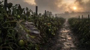
All over Indonesia, in addition to the immediate destructive effects of the eruption, masses of ash, rock particles, and sulfur dioxide gas were deposited everywhere and they continued to give trouble year after year for some time. Sulfur dioxide is a poisonous gas used in the manufacture of sulfuric acid, a highly toxic substance. An invisible gas, the presence of sulfuric acid in the air created complications for the digestive system of both humans and animals and many died as a result. Lack of rain was another consequence of the disaster. Since all vegetation was destroyed, transpiration activity stopped. Normally new soil forms quickly in tropical areas that experience volcanic eruptions and the eruptions contribute to much of the tropical rainfall that comes frequently in latitudes such as those in Indonesia. Accordingly, population there is always dense and crops can be grown two or three times a year in such soil. However, it took several years before Indonesia was able to grow crops of the kind and quality needed to feed its huge population.
The collection of thousands of islands that we now call the nation of Indonesia always had a fascination for the people of Europe, largely the result of the value of spices in centuries past. Marco Polo was the first to acquaint the West with what was then called the Spice Islands. That was about eight hundred years ago but it was considerably later when the importance of spices appeared. By the middle of the nineteenth century and after considerable success in both farming and stock rearing, Europeans were faced with the problem of preserving meat in winter. Animals were slaughtered in the fall to reduce the cost of feeding them and the meat was then salted away in iceboxes to preserve it for six or more months. The taste of salted meat after all that time was, to say the least, not very attractive and Europeans discovered that one specific item from the Spice Islands, pepper, was the thing that would profoundly enhance its flavor. Trade in pepper between Indonesia and Europe became a top priority. So great was the value of this commodity that a single peppercorn was considered to be worth its weight in gold and this became evident in the rules governing stevedores at European ports. Whenever they had to handle peppercorn shipments from Indonesia their pockets were sewn up to minimize theft.
The island chain that is Indonesia extends in a curved form for more than 4,000 miles. Closely following the islands on their south side but deep below sea level stands the tectonic boundary between the Indo- Australian Tectonic Plate and the Eurasian one. The Indo-Australian Plate is moving northeastward beneath and at a slightly faster rate than the movement of the larger Eurasian Plate and this subduction is the main cause of the numerous volcanic eruptions and earthquakes we hear about from Indonesia. Within the overall picture of these two huge tectonic plates, there are smaller components of each that can at times be extraordinarily destructive. The gigantic earthquake of 2004 off the coast of Sumatra was caused by the Indian portion of the Indo-Australian Plate subducting under the Burma portion of the Eurasian Plate and creating one of the most powerful earthquakes of all time. The tsunami that accompanied this event and radiated outward from the entire 750 miles of plate that had been displaced is also likely to go down in history as the most destructive. It was literally an earth-shattering wave and it took several minutes for the displacement to be completed.
The island on which Tambora stood is more than two hundred miles north of the tectonic boundary. The magma that rises from below this boundary has to travel upward about one hundred miles from that boundary and from far below it to reach the summit of Tambora and cause the eruption. It is the work of geologists to trace as completely as they can both the source of the magma and its age. Only by doing this can information be found on the past history of volcanic activity as big as Tambora’s and thereby be able to predict when another one might occur. The sea floor is the top of the outermost solid layer of the earth’s surface, known as the crust, often several miles thick. Below the crust is where the magma exists and there have weaknesses or fault lines in that crust if the magma is going to rise to the surface. One such fault line stretches northwestward for 150 miles from the Island of Sumba across the tectonic boundary to the Island of Sumbawa, the site of Tambora.
It was through breaks in this fault line that magma built up over the centuries. Geologists did not know very much about either tectonic plates or subduction at the time of Tambora’s eruption and it was about 150 years later that the secrets of earth’s mosaic of tectonic plates became known. Ever since that time geologists have been busy making use of this new knowledge to trace the history of earthquakes and volcanic eruptions.
The age of the oldest lava on the site of Tambora is about 50,000 years and the youngest are the layers of ash and rock that were deposited on Indonesia in 1815. Beneath these deposits are some older rocks, about 5,000 years old. This discovery, while inconclusive, gave geologists at least one clue to the likelihood of another Tambora-type eruption arriving soon. If the time difference between the 1815 event and the one that came before it is 5,000 years, then one possibility is that there will not be another one before another 5,000 years.
More work needs to be done by geologists on the history of eruptions in this part of Indonesia in order to obtain the average time between these destructive events over the millions of years through which they have occurred. Only when armed with data of that kind can we estimate the future with some degree of accuracy. The final phase of the 1815 event seems to have begun three years earlier. Reports from local observers tell of noisy steam eruptions, sometimes followed by dark clouds of volcanic ash, happening from time to time between 1812 and 1815. These things were the result of hot magma encountering moisture as it rose within the mountain. Overall, in the course of the three years, there was a two-inch layer of ash on the sides of the volcano and on the ground.