Timeline
Evaluating disaster safety requires analyzing multi-decade empirical records rather than single-year anomalies. The historical framework for federal emergency tracking began in 1953, when the United States government formalized federal disaster assistance through presidential declarations. Examining disaster declarations across different historical epochs reveals how stable low-risk states have remained over time.
Between 1953 and 2026, federal emergency declarations logged every major event where local and state resources proved insufficient to manage recovery. Throughout this 73-year tracking period, high-hazard states repeatedly requested federal intervention. California recorded more than 284 federal declarations due to recurring earthquakes, severe wildfires, atmospheric rivers, and mudslides. Texas logged over 255 declarations, driven by frequent Gulf Coast hurricanes, severe flash flooding, and catastrophic winter power outages.
In stark contrast, the historical record highlights the exceptional stability of the lowest disaster risk states. Delaware accumulated only 21 total federally declared disasters between 1953 and 2026, marking the absolute lowest total of any state in the nation. Rhode Island secured the second-lowest position over the same timeframe with approximately 22 declarations. These historical figures confirm that these small Mid-Atlantic and New England states rarely suffer localized disasters large enough to overwhelm state emergency management capabilities.
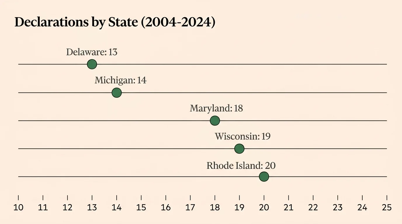
A closer examination of 20-year trend data from 2004 to 2024 demonstrates that these historical safety patterns remain consistent in modern history. Over this 20-year period, Delaware again logged the lowest number of emergency and disaster declarations nationwide, recording only 13 events. Michigan recorded the second-fewest declarations with 14, followed by Maryland with 18, Wisconsin with 19, and Rhode Island with 20. These figures illustrate that northern Great Lakes states and select Mid-Atlantic regions enjoy sustained periods of operational stability uninterrupted by massive natural destruction.
During the early 2020s, federal risk assessment underwent a major technological shift with the deployment of the FEMA National Risk Index. Prior to this shift, public understanding of disaster risk depended primarily on post-disaster funding records. The NRI introduced advanced geographic information systems (GIS) and localized census-tract data to map physical exposure across eighteen hazard types simultaneously. This shift confirmed that midwestern inland states like North Dakota, Nebraska, South Dakota, Kansas, and Montana represent the absolute lowest composite risk zones in the nation, providing a reliable geographic roadmap for long-term safety planning.